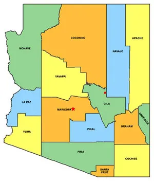
 The red dot on the location map shows approximately where Q Ranch is located. It’s near the northern edge of Gila County, about 3 miles east of Navajo County and 6-7 miles south of Coconino County. If you have a GPS device, the latitude and longitude are 34° 03' 21" N and -110° 48' 23" W.
From Central Phoenix (Central & Camelback) it’s 147 driving miles. The one-way trip takes about three hours, allowing for a brief stop.
However you get here, you will be driving on unpaved roads for the last 20 miles. The final 8 miles, Forest Service Roads 202 and 202a, is not maintained with any regularity by the County. If it has rained recently, the last 2 miles can have deep ruts and be very slippery.
The rule of thumb is this: if the road is wet and muddy, drive in the ruts; they will keep you on the road. If the road is dry, stay out of the ruts. You do not need 4WD for the unpaved roads, but a high clearance vehicle is a plus.
Click the link below to download a one-page PDF with illustrated driving directions.